Necessary Options /
Adventure Home /
Minnesota Index /
<- Previous /
The Tail of the Trip - Back to the Start - but not Directly
Saturday, August 18 Itasca to Hackensack 52mi FREE
The wonderful weather prediction is for tailwinds for the weekend. I'm headed
back through Walker to see how far south I could get.
On my way out of Itasca Park, I came to a food station for an Ironman ride.

No, not THE Ironman competition, but a catered ride sponsored by Hostling Minnesota.
The food they offered me served as my breakfast.
Headed east on US71, I start with ONLY a 6 foot shoulder. I left about $12 at a
Lake George gas station getting food and a bag of ice.
When US71 turned north, I took MN 200 south and still had an adequate 4 foot shoulder.
I stopped in Walker one last time to chat with Paul Nye, then restocked my food supply
at the Super One.
I took MN 371 south towards Hackensack, intending to rejoin the Paul Bunyan Trail
as soon as it was no longer hilly. The shoulder was adequate, the traffic was low,
and the rummor was that this section of the trail had the poorest maintenance,
so I just stayed on the State Highway.
In Hackensack, I stopped at Mark'S Market asking about a place to camp. The manager
said I could camp in the grassy area in back, but also said there was a picnic pavilion
along the trail. The grass behind the grocery was long, with no place to charge my phone,
so I decided to move to the pavilion.
It was Saturday; there was no official place open to ask permission to use the pavilion.
A storm was brewing,

so I went to the Lucette Restaurant/Bar, named after (wait for it)
- Paul Bunyans girl friend.

The barmaid said people stay there all the time, so it would probably be OK.
As I was leaving, there were some people inside the entrance. As I listened in,
I noticed one lady with a thick accent. When she started talking about serendipity,
I interrupted. I asked her to come outside in the rain and see my bike.
"Sarah Dipitee" is the name I had given the bike, and I showed that to her on the
decal on my pump.
Her name was Maha, and her reaction was to call her husband Brian to come and meet me.

She had been talking about serindipity all day. What a coincidence. They wanted to
take me to dinner someplace miles away, but I couldn't leave without my gear, so
they decided to eat where we were.
Maha is originally from Morocco and is named after the Impala deer, known for its beautiful eyes.
She was recruited in France to be a manager at General Mills in Minneapolis.
She was in Hackensack with friends for the holiday. They provided me with good
conversation, dinner, and the opportunity(?) to set up my tent after dark in the park.
I had a little difficulty getting to sleep, not because of the rain (I was under
the pavilion and there was no thunder/lightning), but the owner of a car parked
in front of the bar across the street was not very quick to turn of their car alarm - repeatedly.
Sunday, August 19 to trailside camp south of Merrifield 41mi FREE
I awoke to the sound of birds close to my tent. Sweet? I was able to stick my head out
of the tent and get a picture.

Breakfast was at the American Legion across the street.
After less than an hour of riding, I came to the quaint, little town of Bacus.

It had a carved "statue", and boy was it corny.

The scenery varied. Further on were these field stone fences
and this bridge over a wetland.

This was the second half of my grilled cheese sandwich at the Merrifield Diner.

They had a flyer for the Woodtick Theater.

I also chatted with a lady and her dad.
I moved on down the trail and ultimately set up camp alongside the trail south of Merrifield.
 Monday, August 20 to Crow Wing State Park $28 25mi
This day would bring me to the end of the Paul Bunyan trail, and the end of that
level of serenity. I was realizing my trip was nearing its end, a situation I
wasn't ready for, but had to accept. On previous trips, I always got to this
mental state, but there was always at least one memorable moment to come.
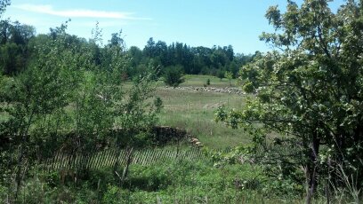
Here is some more trail scenery.


Trails all have a lot of private intersections. Here's one now:

As I approached Brainerd, a man on a tricycle said something to me as he passed
going the other way. I turned around to ask him what he had said, and that turned
into a long conversation. He had retired in his late 50s with a $3500/month pension.
He was now 80 and figured he could afford the trike (said with a big grin).
Minnesota is known as the "Land of 10,000 Lakes. Are these two of them?


In Brainerd,a recent addition to the Paul Bunyan trail is a bridge over a busy road.
It extends the trail another 3 miles to Central Lakes College.

This is from the Super One Foods store, which is obviously off the trail. As I sat
outside eating lunch, a lady approached me. She and her dad had chatted in the
Merrifield Diner. Having people see me multiple times is by no means a unique situation.
I returned to the trail and rode into Brainerd to catch MN 371 South.
South of Brainerd, I stopped at a gas station / convenience store for supplies.
Just beyond it was a cloverleaf interchange. When I took the exit, I found myself
in a residential area with no roads south. Consulting the map on my smart phone,
I abandoned the wild goose chase, and returned to the main route, a limited access,
divided highway.
Camping at Crow Wing State Park was unremarkable.
Tuesday, August 21 Stealth police escort in Little Falls 29mi $28
Here's what riding down busy MN 371 was like. The shoulder was only nine feet wide.

The scenery was huge, if you're into sprinkling systems:

My entrance into Little Falls was both early, and observed at several points by
the local police. I found this out when I visited the police department to get
directions to the library.
With a bit of time to let my mind wander, I got to thinking about my favorite
History Channel program: American Pickers. They are located in Le Claire, Iowa.
Would I be able to take the long way home for a visit to their shop? With access to
the library's internet connection, I calculated it would only add about 100 miles. That is
a couple hours driving and $20 in gas. Heck yes. So the end of my trip would get
a new ending, with me becoming a tourist rather than a traveler.
I stayed in Charles Lindburgh State Park, another adequate, if not overpriced facility.
Wednesday, August 22 Tanks in Opole; Holdingford had tanks, music, and sculpture FREE 41mi
Just outside the park was the Lindburgh mansion.

My intention was to go south along the Great River Road to Rice, then west to
Holdingford to pick up a rail trail, and ride it southwest to the park in Albany
where I stayed my first night.
About 8 miles into my ride, something happened. I came to the intersection of a
paved rail trail. I knew of the abandoned railroad line, but not that it had been
paved this far from Albany. (It turned out to be the Soo Line, an extension of the
Lake Wobegon Trail.) I could take this through Bolus to Holdingford and get
more rail trail riding than I expected.
Before I could get started, someone else came along. They pointed out that it had
also been paved in the other direction (I could see that) all the way to to US 10
(I couldn't see that). I could take US 10 south to Royalton, where there were a lot of
bald eagle nests. What to do?
Of course, I headed to Royalton. As a bonus, this new trail crossed the Mississippi
River, in front of a large dam.

When I got to US 10, the rail trail had a bridge over it, and a real railroad was being maintained along it.

The traffic and shoulder on US 10 were less than perfect.

When I got to Royalton, I bought a sandwich and ice at the EZ STOP and discovered
that crossing the Mississippi didn't mean that I was out of Minnesota and into
another state.

I also found that the nests were not in town, but too far for me to see this day.
I had to plot a route to get me south to Rice (where lunch would have been, had it
not been for this wild bald eagle nest chase), recross the Mississippi, then join
my planned routento the west at Holdingford.
On the way to Rice, I met a couple riding recumbent tricycles. They planned their
vacations around doing loop rides from a campground, and were headed back to their
home away from home when I met them. They would be the only other recumbent riders
I would see on the whole trip.
Here's the Mississippi looking downstream from west of Rice.

The western sky revealed the makings of a storm coming my way as I approached Opole.

By the time I got there and ducked into the convenience store/bar, I was drenched.
I learned the factory just across the street made stainless steel tanker bodies.
When mounted on semi-trailers, they were used to haul milk and other liquids.
A half hour and an ice cream sandwich later I left.
The factory was letting out, and I caught a picture of the backside of the storm after
I pulled ovrer to let traffic pass.

I've never seen clouds this low, this close.
Holdingford had country music playing on power pole speakers. I passed another
factory making stainless steel tanker bodies. The Hardware Hank store was
open. I gave it a visit and found this calf feeder for less than $700.

If I bought it, I'd have to buy a calf, and I didn't have room on the bike.
The northern extension of the Lake Wobegon Trail goes through Holdingford. As I left town, I couldn't help but notice these stainless steel sculptures. It seems that some of the workers can do more than make tanks.
 This guy guarantees at least one spectator.
 to THIS

 This is a tribute to logging before chain saws and trucks.

 Putting the choir girls next to the corn still was an interesting choice.
 Methinks a more believable sequence would be: Making Spirits, Getting Plowed, Children to Follow

 Summer/Winter Sports - OK Steam Engine charging Bicyclist on a Rail Trail - scary
As if putting frosting on the cake, looking down the trail, I see:

The ride south to Albany brings more eye candy.


After returning to Albany and setting up camp, I rode some more. I went east on
more of the Lake Wobegon Trail to Avon. As much as I searched, and asked around,
I could not find a statue of that Lady.
Thursday, August 23 185 trail toads to Eagle Lake 53mi FREE
The idea today is to basically retrace my day 1 route, but plans sometimes want to
be changed. So, the first stage is to get to Paynesville.
This day was a good one to see a lot of cattle on the road - in cattle trailers.
I don't know whether they were going to market, to a rodeo, or what.
When I got to the town of Roscoe, I had a flashback. Remember, Roscoe is the little
town with the big hill with the stop sign at the bottom. Maybe I could find a way to
avoid climbing that hill and still get to Paynesville.

It doesn't look so bad, and it wouldn't matter if there were a stop sign at the top,
but I just want to outfox this inanimate object. I figured I could just go back to
the first road going west and catch the next paved road going south.
Crossing my fingers on this one was not a good plan. After several miles of finding
unpaved crossroads led me to check the map on my smart phone. The first paved road
south would have had me overshooting Paynesville by several miles, eliminating my
chance to get lunch and do laundry. So, I turned around, went back to Roscoe, and
climbed the hill, which wasn't so bad after all.
In Paynesville, I used the Lakes Area Laundry, where the owner had an unusual attitude. They
had upped the minimum charge for a load in the dryer, and my clothes came out real
close to crispy, not to mention over budget.
The last leg of my trip was to be about 7 miles shorter, based on my car having
been moved to Eagle Lake, the home of a friend of my daughter.
I spotted a rabbit on the trail ahead with a leaf in its mouth. Seeing me, the
rabbit unburdened itself of the leaf and disappeared off the edge of the trail.
South of Spicer, I started seeing, and counting, small toads. They were on the trail and the
street I turned onto. I counted 185 toads. Yeah, I was bored!
I got to the next to the last road and incorrectly turned left, providing me
with an unnecessary mile and a half. The first part was a wonderful downhill and ...
I got back on track and encountered a hill that required my full concentration
to climb - so much that I missed the street sign of the street where my car was.
Of course, the sign was at the top of that hill, and I was able to get to the bottom of the
hill before realizing my situation. I enlisted a homeowner in the area to drive
back and try to spot my car. They did, and I eventually arrived.
The place I would take my gear and set up my tent was the second terrace down,
connected by a lot of steps to go down and up after another long day. I finished
getting the gear down and the tent set up as the owners arrived.

Fortunately, I was able to follow that with a long overdue shower, a nice view of the lake,
and a good time with my hosts.
 Friday, August 24 RAGBRAI road and Scales Point drove $21.20
Iowa holds one of the biggest week-long cycling events in the US with over 15,000
riders. Participation is by lottery; half get to ride all the way across the state,
and the others choose just a day or two. All they get is the right to be on roads
that are closed to traffic the day they pass through. Food and lodging are extra.
I found a road that was used earlier in 2012, just to get a feel (more like one
touch of a part of an elephant). Here is that road, with views looking north and south.


I had trouble finding a campground, but as it started to get dark, I found Scales Point.
I met the owners, who told me the normal place they would have put me would be
next to a wedding party that would be loud into the night. Instead, he put me in
his own "backyard".

You can see his home way back there. I was favorably impressed with this campground,
and the young couple that own and run it.
Saturday, August 25 LeClaire, IA, then home
I found the Antique Archaeology shop in LeClaire, but Mike and Frank, the two
American Pickers stars that travel to find and buy old stuff, were on another road
trip, this time in upstate New York. And the shop was so loaded with tourists that Danielle
couldn't get anything done, so she was elsewhere. The shop was loaded with stuff,
but a lot of it was not for sale. Disappointed, I only bought a mouse pad. It won't be an
antique for a looong time.

Update: on a recent show, they were planning on adding a second building to the property.
On the way back to my car, I noticed a huge picture of Danielle hanging on the side
of a two story home. (She is the hot and much-tatooed lady that finds the boys leads,
arranges appraisals, and much more.) I thought that it was rather crude and rude
for someone to set up a store so close to where fans would pass to take advantage
of Danielle's fame.

I decided to go in and see what was up.

The store is called 4 Miles 2 Memphis. It mainly has clothing and jewelry made by the owner.
As I was looking around, someone came down the stairs. It was Danielle; she owns
the place and came to mingle.
Her daughter, who worked in the store, took my camera and took a picture of us.

For my sister Alice, I bought a set of ear rings Danielle had made, and a poster for my
refrigerator. As we stood talking, she fished for a compliment. "I wish I had your
skin." Now my skin has tanned wrinkles, appropriate for a man in his late 60s.
I made her an offer. "I'll trade you half my skin for half of your tatoos."
She didn't like the offer. In spite of that, I found her to be very nice and
easy to talk with.
As it turns out, Danielle and Mike are friends from way back. Danielle had her store
there first. When Mike had to be away, he asked her to "keep an eye on his store".
As time passed, she became more involved with Antique Archeology.
Now, it was just a lot of driving to get home to my two cats. I am thankful that
the police departments along the way appeared to be all underfunded. ;-)
Necessary Options /
Adventure Home /
Minnesota Index /
<- Previous /